Hurricane Ian Tracker: Florida braces for catastrophic landfall

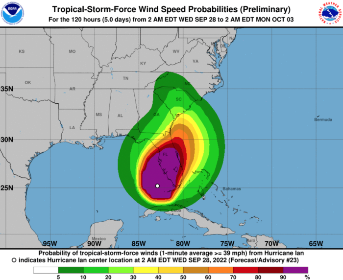
After leaving 11 million people without power in Cuba, Hurricane Ian became a catastrophic Category 4 hurricane early Wednesday with winds up to 155 mph as it moves closer to Port Charlotte and the southwestern coast, where it's expected to make landfall by the afternoon and is predicted to cause life-threatening flooding.
Millions of residents are bracing for storm surges, catastrophic winds and flooding as the landfall of Ian’s center is expected to occur Wednesday afternoon between the Sarasota, Port Charlotte, Fort Myers and Naples areas, The Weather Channel said.
Ian is likely to remain a dangerous Category 4 hurricane through the time of its landfall, according to the U.S. National Hurricane Center, which said at 5 a.m. Eastern time, when the hurricane was about 75 miles off the coast, that the center of Ian was moving north-northeast toward Naples about 10 mph.
The storm surge is predicted to reach 12 feet if it peaks at high tide in western Florida, and rainfall near the area of landfall could top 18 inches, according to The Associated Press.
As Ian moves over the central Florida Peninsula Wednesday night, it might weaken to a tropical storm before possibly emerging over the Atlantic waters by late Thursday and then turn back toward the Georgia or South Carolina coasts as a tropical storm later in the week, it added.
Due to persistent onshore winds as Ian’s center moves farther away, coastal flooding might last for some time beyond the peak storm surge into Friday or even early Saturday in western Florida and along the Atlantic Southeast coast.
A storm surge warning — which means life-threatening flooding from rising water moving inland from the coastline is expected — was in effect from the mouth of the Suwanee River to the southwesternmost tip of the Peninsula, including Tampa Bay, according to the U.S. National Hurricane Center.
“It’s been around 100 years since Tampa had a direct hit. They’ve just been lucky for a long time,” Erik Salna, associate director of the International Hurricane Research Center told BBC.
The warning was also in effect on the Atlantic side of northeast Florida, from the Flagler-Volusia County line to the Georgia state line, including the St. Johns River.
A storm surge watch — which means a dangerous storm surge is possible in 48 hours or less — extended northward along the Georgia and South Carolina coasts on the Atlantic side, as well as the Florida Keys.
Tornadoes are possible today and tonight across central and south Florida.
Florida Gov. Ron DeSantis issued a warning Tuesday, pleading with those in an evacuation zone to leave, saying “now’s the time to act.”
By Wednesday morning, more than 2.5 million residents of Florida from coastal towns and cities had begun to evacuate, and police were going door-to-door in some areas urging them to leave, BBC said.
Early Tuesday, Ian made landfall southwest of the town of La Coloma in western Cuba’s Pinar del Río province, with maximum sustained winds of 125 mph, NBC News reported, adding that, by the evening, the entire island was without power.


